
Aerial Survey Services
We offer advanced aerial survey services that provide detailed topographical information for large-scale projects.
What is aerial survey used for?
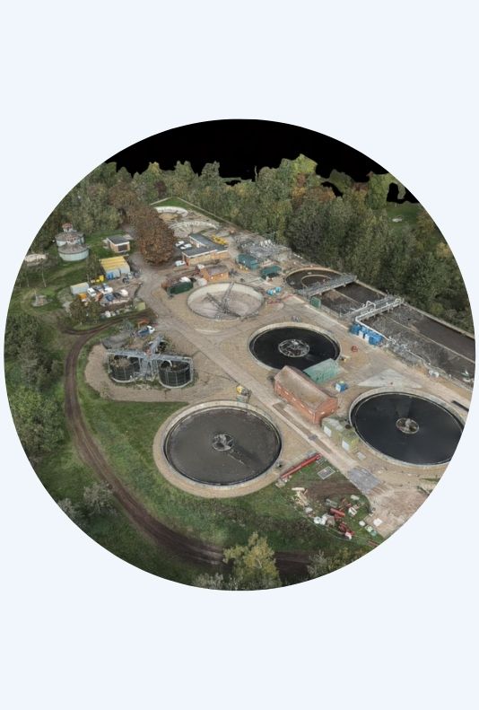
Using the latest technology, we capture extensive geographic data with 3D LiDAR and high-resolution orthophoto techniques.
Our services are perfect for road planning, airport projects, railway routing, and other initiatives that need comprehensive topographical data. We offer a variety of applications, including:
- 3D topographical photogrammetry and modelling surveys
- Route surveys for highways, pipelines, and overhead lines (OHLs)
- Floodplain and coastline surveys
- Infrastructure inspection surveys
- Construction site progress videos

Talk to our experts

Our Methods
Aerial Surveying
Benefits
Cost-effective: Aerial surveying is the most financially viable solution for large-area topographical information.
Rapid data collection: Our drones deliver extremely fast and efficient collection of survey data.
Minimal access requirements: We can survey areas with little to no access needs, ideal for challenging terrains or restricted sites.
Quick turnaround: Data can be processed and delivered promptly following capture.
High accuracy: We use advanced technology and software to ensure precise and reliable results.
Versatility: Suitable for various applications, from 3D topographical modelling to infrastructure inspection.

Check out our News & Media
Other news

SOCOTEC UK Leads the Way with SQ P3 Concrete Project
Read +
SOCOTEC Drilling Academy Celebrates New Milestone: Our Second Graduate has Completed the Programme
Read +
Ground Investigation Data Goes Fully Digital
Read +
Updated BDA Guidance for Working on Potentially Contaminated Sites
Read +
FAQS: Bioremediation Field Application
Read +
FAQ's: Your Guide To Understanding The Requirements Around RAAC
Read +
SOCOTEC UK submissions shortlisted for the 2023 Ground Engineering Awards
Read +
